A short history of the Danube
(Reading time: 5 min)
The history of the Danube dates back to the Upper Miocene (approximately 5–10 million years ago). At that time, the formation of the Alps, caused by the collision of the European and the African-Adriatic tectonic plates, was well advanced. North of the rising mountains, the Molasse Basin (Learn more) had formed — a depression that filled with sediments from the Alps (Learn more).
Further contributions on rivers can be found under Temporality and Vitality of Rivers.
When the Danube originated in the Alps
In the region of today’s Swiss Plateau and the southern German Alpine foothills, further uplifts occurred that repeatedly altered the courses of rivers and their drainage basins. It was here that the precursors of today’s river systems — the Rhône, Aare, Doubs, Rhine, and Danube — developed.
With the further uplift of the Jura Mountains (Learn more) (approx. 7–3 million years ago), a barrier was formed that redirected water flow eastward — giving rise to the Ur-Danube (ancient Danube). Its source was likely in the Aarmassif (Learn more); the upper Rhône may also have flowed into it.
Significant tributaries at the time included the Alpine Rhine, which still flowed into the Danube at that point (Learn more), as well as the „Feldberg Danube“, which originated further north in the Black Forest. Feldberg is the name of the highest peak in the Black Forest.
In the later Pliocene (5–2.6 million years ago), further tectonic uplifts altered the Danube’s drainage basin. Around 3.5 million years ago, the Aare began to erode the southern Molasse Basin more intensely. The uplift of the Black Forest and its southeastern foreland blocked its original northeastward flow. Near Waldshut, it found a new outlet to the west, merged with the Ur-Doubs, and flowed into the Mediterranean via the Rhône — the so-called Aare-Sundgau system (also known as the Aare-Doubs system).
As a result, the Ur-Danube lost large parts of its drainage area. Its main tributaries now became the Alpine Rhine and the Feldberg Danube, the latter becoming the Danube’s new source river.
The following illustration shows the reconstructed course of the Rhine and Danube river systems at the transition from the Miocene to the Pliocene (approximately 5–6 million years ago), on the left, and at the transition from the Lower to the Upper Pliocene (approximately 4 million years ago), on the right.
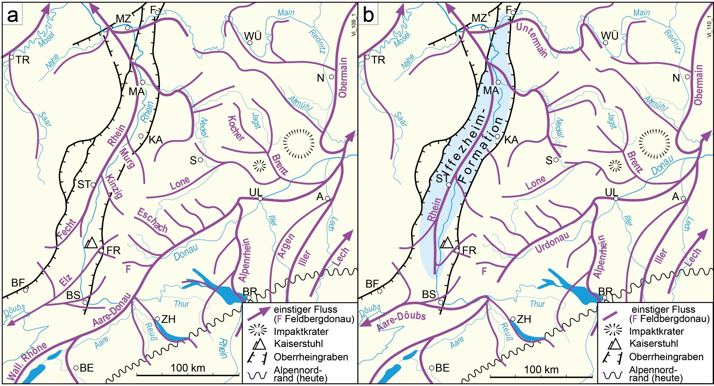
This illustration was taken from the following webpage of the Regional Council Freiburg, State Office for Geology, Resources and Mining (Regierungspräsidium Freiburg, Landesamt für Geologie, Rohstoffe und Bergbau): https://lgrbwissen.lgrb-bw.de/bodenkunde/suedliches-oberrheinisches-tiefland-hochrheingebiet-klettgau, accessed: 25.07.2025, © Regional Council Freiburg, LGRB.
The Danube in the Pleistocene
With the beginning of the Pleistocene, 2.6 million years ago, the course of the river changed once again: due to the continued subsidence of the Upper Rhine Graben, the Aare now flowed northward into the Rhine — and thus into the North Sea.
Whereas tectonic processes had mainly shaped river courses up until then, it was now — starting with the onset of glacial–interglacial cycles (Learn more) — climate-driven changes that became dominant. The Rhine Glacier, which formed in the Alpine foreland, dammed western tributaries such as the Thur around 1 million years ago. During cold periods, meltwater flowed across the watershed into the Aare-Rhine system; during warm periods, drainage into the Danube was at times possible again.
With the carving of meltwater channels and the last tectonic movements, the Alpine Rhine permanently shifted westward. Around 450,000 years ago, the Danube lost this tributary for good. The Alpine Rhine now belonged fully to the Aare-Rhine system. The watershed between the North Sea and the Black Sea shifted further east; the Feldberg Danube remained as the most important source river of the Danube.
The following illustration shows the reconstructed course of the Rhine and Danube river systems at the transition from the Pliocene to the Pleistocene (approximately 2.6 million years ago), on the left, and during the Early Pleistocene to the early Middle Pleistocene (approximately 2 to 0.5 million years ago), on the right.
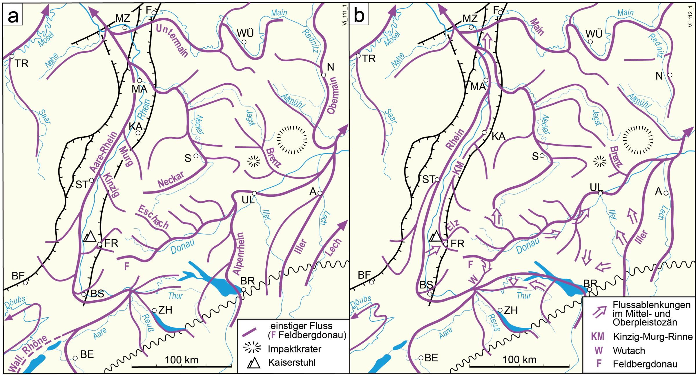
This illustration was taken from the following webpage of the Regional Council Freiburg, State Office for Geology, Resources and Mining (Regierungspräsidium Freiburg, Landesamt für Geologie, Rohstoffe und Bergbau): https://lgrbwissen.lgrb-bw.de/bodenkunde/suedliches-oberrheinisches-tiefland-hochrheingebiet-klettgau, accessed: 25.07.2025, © Regional Council Freiburg, LGRB.
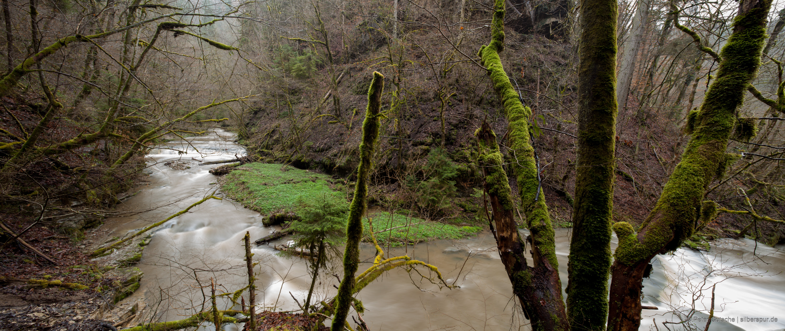
The formation of the Wutach Gorge
A particularly dramatic change occurred around 18,000 years ago during the last major glaciation. The Wutach, a tributary of the Upper Rhine, carved its way northward toward the Feldberg Danube through headward erosion. This process was aided by the steep gradient of the Wutach, as the Upper Rhine had already deeply incised into the landscape.
When the erosion front reached the watershed — intensified by dammed meltwater — a sudden breakthrough occurred, possibly lasting only weeks or months. The Feldberg Danube was diverted into the Wutach Valley and thus southward to the Upper Rhine. This led to the formation of the nearly 200-meter-deep Wutach Gorge and the characteristic „Wutach Bend“ (Wutachknie) near Blumberg.
This panoramic photo, taken from Buchberg above the Wutach Bend, provides a vivid impression of the region’s topography (Learn more).
This event may have taken place in the presence of early humans (Learn more).
Today, the Danube rises near Furtwangen at an elevation of around 1,100 meters on a high plateau in the central Black Forest. Here is a night-time photo of this remote location:

In the photo, taken on a summer night facing north, the band of the Milky Way is visible, while the Andromeda Galaxy appears as a faint, misty spot in the upper right. This galaxy is the most distant object visible to the naked eye and is located about 2.5 million light-years away. That means the light we see from this stellar system today was emitted long before the source river of the Danube ever flowed here in this peaceful corner of the Black Forest (view the photo in higher resolution).
Even during the Holocene, the Wutach continued cutting into the bedrock — a process that continues to this day. It is one of the few remaining wild rivers in Germany and offers a striking example of the dynamic, living nature of a flowing body of water. In its upper course, this river has carved into a sequence of rock layers of varying ages (Learn more).
And What About the Future?
We’ve seen that the drainage basin of the Danube river system has steadily shrunk over time, and that the watershed between the North Sea and the Black Sea has gradually shifted further east. This process appears to be ongoing — and is likely to continue in the future.
One phenomenon that illustrates this shift is the Danube sinkhole near Immendingen. Here, water from the Danube disappears underground into karst rock and reemerges at the Aachtopf spring. From there, it flows as the Radolfzeller Aach into Lake Constance. This phenomenon highlights how the Rhine, due to its lower elevation and gradient, increasingly captures water from the Danube — a process known as river capture.
Additionally, a small stream currently draining into the Wutach near Blumberg — the Schleifenbächle (Learn more) — is expected, through headward erosion, to gradually carve its way northeast via the Aitrach Valley toward the Danube. This means that, in the distant future, the Danube could be diverted toward the Rhine near Geisingen (Learn more). By then, the city of Donaueschingen might need a new name...
If this development continues, the source of the Danube may shift even further east.
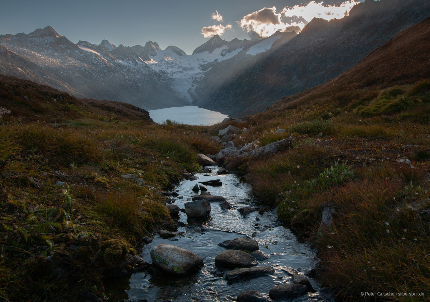
The Inn — which originates in the Alps and joins the Danube at Passau — could eventually become the Danube's primary source river, when measured from its mouth at the Black Sea (Learn more).
This would essentially be a return to conditions during the Pliocene, when the Aare-Danube system also originated in the Alps. An intriguing thought.
However, we must not overlook one crucial aspect: with the warming of Earth's climate, most Alpine glaciers will vanish within just a few decades (Learn more), and a return to cooler conditions is not expected for thousands of years (Learn more). Therefore, the Alpine region may eventually lose its importance as a source area for the Danube system. Climate change is fundamentally altering water availability in the Alps: glaciers are melting rapidly, and their contribution to the Danube is already declining.
This article was originally written in German. The English version was translated with the assistance of AI and subsequently revised for clarity and accuracy.